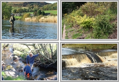
We received a call last week about erosion on the Lugar Water upstream of Ochiltree. The banks have been collapsing at an alarming rate in recent years with tonnes of soil adding to nutrient enrichment downstream (diffuse pollution). We were previously aware of the problem but this was the first time the landowner had requested our assistance on this matter. I took the dog a walk on Sunday to refresh my memory of the situation. In 2008 when I first saw the eroding bank I remember watching sand martins flying in and out of their nests along a 200m+ stretch of exposed soil. I sat at the bank top to eat my lunch with gorse bushes behind me. On Sunday, there were no gorse bushes to be seen. The pool was nearly double the width that it was in 2008. This is serious erosion.
I downloaded images from 1945, 1999 and 2004 from Google Earth. Even the changes between 1999 and 2004 were obvious. Unfortunately until Google Earth updates with a more recent image (or the Trust pays for a helicopter ride) these are the most up to date images I can work with. The contrast between the 1945 and 2004 image reveals the source of the problem. Around 1970, the river was diverted along a newly dug channel. An old meander that was over 1000 metres long was cut off and replaced by a straight channel of around a third the original length. The river flows straight into the eroding bank with nothing to dissipate the energy of the flow. I understand from the retired farmer that this was done by the Coal Board, possibly to prevent the Barony Bing eroding.
The old meander is still largely intact although now overgrown and weeded.
Perhaps the solution may lie with reverting the river back to its original course but this would take considerable investigation and even greater resources.
It would make a fascinating project in line with the latest thinking on flood attenuation and restoration. Watch this space for updates (but not too soon)!


Interesting! I think there has been far too much moving of burns and rivers (both in Ayrshire and generally) to suit ‘infrastructure’, coal excavations etc. The chickens are coming back to roost . . .
I was up at Croilburn (west end of Whitelee) last week (I had to climb over a locked gate to where turbines are being put up). The burns and settling reservoirs had a bit of pollution. A waterway next to Croilburn itself had a horrible grey-brown colour.
At the w/e I was up at Pogiven Bridge, once a remote and lonely spot,beyond Brocklees and Long Green farms. Several new turbines near there now. For the first time ever, the Pogiven Burn was polluted – quite a bit. It empties into the Glen water.
Today I wandered through Morton Park in Darvel and saw lots of pollution in the River irvine-again more than I have ever seen. I thought that River Bailiffs and the fishing club kept a watch on the R. Irvine?
Sorry about the pessimistic news!
Best wishes,
Ruth
Thanks for your comments Ruth. I will try to find out what is going on to cause the pollution on the Glen and Upper Irvine. If you ever see anything that gives cause for concern, let me and SEPA know as soon as possible. SEPA’s number is 01292 249000. There is a call divert in place at weekend so you still get though to an officer. The more people that phone it in the more likely it is that someone will attend.
Regarding changes to burns over the years, yes it is a big problem and one has to wonder if it is in some way linked to the loss of sea trout across Ayrshire. I’m sure it hasn’t helped.
Last week I came across a burn that had been ditched out for at least a couple of hundred metres. There were stacks of large bore plastic pipes next to the freshly ditched channel. Needless to say the intention was to put the burn underground. I contacted SEPA and will follow up with them next week to see what has been done about this. This type of activity is highly detrimental but sadly not uncommon. Given the publicitiy that has surrounded Controlled Activity Regulations over the last few years, I find it incredible when we hear the excuse ‘I didn’t know I couldn’t do that!’ Ignorance may be bliss but it’s no excuse.